
Key information for decision-making after one of the largest disasters that occurred in the country during the last 30 years, was generated by a team of researchers and professionals from the Research Center for Integrated Disaster Risk Management, CIGIDEN reported.
With the support of the Planning Secretariat (SECPLA) of the Municipality of Viña del Mar, they remained for three days carrying out a damage registry in the affected area of the Viña del Mar commune.
The research team, also made up of professionals from the UC Observatorio de la Costa Center and the UDLA Space Production Center, carried out a mapping of the affected areas with the support of satellite images, as well as a survey of critical infrastructure and urban equipment. Along with this, a survey of the main exposure and vulnerability factors for the population was carried out, as well as the requirements and testimonies of the people affected after the emergency.
Damage registry
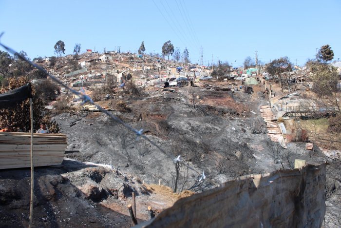
The results allowed us to determine the area burned during the incidents, equivalent to a total of 9,215.9 hectares covering urban, agricultural and forestry sectors in 5 communes of the Region: Valparaíso, Viña del Mar, Quilpué, Villa Alemana and Limache. In Viña del Mar, the fire burned 45% of the grassland-shrub cover and 10% of the built land, estimating a total of 9,828 buildings affected in the commune. The fire affected 34% of the surface of the Viña del Mar commune, with a significant part of built land and 38% of the communal surface of Valparaíso.
Carolina Martínez, principal researcher at CIGIDEN and director of the UC Observatorio de la Costa Center, who led the scientific work in the damaged area, explains that a registry of infrastructure damage was generated through 136 points raised on the ground in the main affected sectors. . The sectors that concentrate the greatest impact due to total loss are: Los Almendros B, Villa Independencia, Villa Arauco, Alto Horizonte, El Olivar I, El Olivar II, Villa Hermosa and Villa Rogers.
The level of damage to critical infrastructure observed during the investigation, meanwhile, established 46.8% with partial damage (46.8%) and 53.2% with complete damage. This includes industries of various types, including Tricolor and manufacturing companies (29.8%), as well as areas with public lighting poles (23.4%), public transportation such as bus booths and train lines (6, 4%), high voltage towers (4.3%), a school and a CESFAM (2.1% of the total respectively).
Regarding the level of damage to neighborhood and urban equipment verified during the tours in the affected areas, it is established that 42.1% had partial damage and 57.9% had complete damage.
Self-organized community
Carolina Martínez adds that among the causes that made the evacuation difficult, causing the loss of human life, were “the irregular layout of streets, the collapse of critical networks (electricity and water), spontaneous urban growth, the materiality of the buildings, the lack of fire drills, the management of substances that aggravate fire (power lines, gas cylinders) and the lack of resilient urban design (evacuation routes, expedited routes for firefighters).”
Rodrigo Cienfuegos, Director of CIGIDEN and UC Engineering academic, explains that as a result of this research, it was also possible to confirm once again the community’s capacity for self-organization, “especially through neighborhood associations, identifying elements of social resilience that could reinforced with local risk management programs. Along with this, multiple efforts were observed for self-managed reconstruction, on hill slopes with strong alteration of slopes and removed soils. These efforts arise naturally in the response to the emergency, but we should improve the way of channeling them through formal institutions and thus correct structural problems identified transversally in order to carry out a reconstruction that controls or reduces the risks.
The report also highlights that none of the affected communes have updated their Regulatory Plans (Valparaíso, 2018; Viña del Mar 2016; Quilpué, 2014 and Villa Alemana, 2002), while the determination of risk areas (especially forest fires) has not been updated. has been articulated to these.
Conclusions and recommendations
Rodrigo Cienfuegos emphasizes that “it is necessary to strengthen territorial planning in these communes, which present complex scenarios due to their geographical characteristics and forms of occupation, especially the strong increase in occupations and camps that make the evacuation process in the event of fires more limited and also because They include construction typologies that are more vulnerable to fire,” he explains.
The research concludes that in the current context of climate variability and change, inter and transdisciplinary studies are required that allow modeling the fire threat and considering vulnerability and exposure factors with integrated approaches, in order to generate risk scenarios for the taking of decisions. “However, any new development in our country should consider a multi-risk analysis at a basin scale, since reconstruction that considers only the latest disaster will sooner rather than later face threats not considered in the plan,” adds Cienfuegos.
A series of recommendations are also incorporated for the prevention and management of risk during fires, highlighting that the reconstruction process that ensues could be an “opportunity to incorporate resilient urban design as well as strengthen preventive culture through emergency plans and education.” to the population”.


 trapped facing municipal re-election")

